The Interoperability Problem at the Tactical Edge: Why It’s Still Unsolved
TAK is a powerful platform. But when your geospatial ecosystem doesn’t speak the same language, critical data disappears exactly when it matters most.
The Problem No One Talks About Enough
Tactical geospatial has a dirty secret: the platforms that operators trust most are often the ones least capable of consuming the data they actually need.
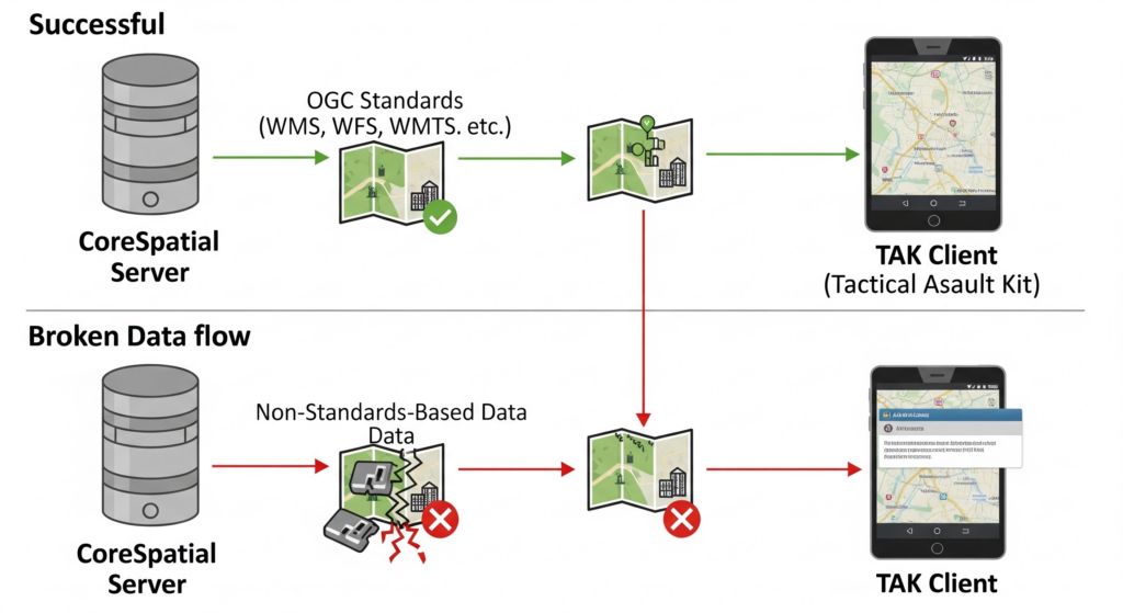
TAK (Tactical Assault Kit, or Team Awareness Kit depending on your community of interest) is one of the most widely deployed situational awareness tools in special operations and beyond. It is powerful, battle-tested, and increasingly adopted across the public safety sector. But it has a major flaw that creates real operational risk: the Common Operational Picture (COP) it provides often fails to properly implement and support standards-based geospatial content.
This means mission-critical data that is standards-based simply vanishes. The layer loads, but the operational picture remains incomplete. The analyst sees nothing. The operator makes decisions without it.
Why This Keeps Happening
The root cause isn’t poor engineering. It’s an ecosystem that has grown faster than its standards.
Modern geospatial workflows pull data from dozens of sources: commercial satellite providers, organic sensor feeds, open-source intelligence layers, allied force feeds, and legacy enterprise systems. Each has its own format, its own metadata schema, its own coordinate reference assumptions. TAK was built around a specific operational model. When data arrives from outside that model, integration breaks.
This creates a lot of point-to-point bridges — custom integrations that work until they don’t, maintained by individuals who may rotate away, and undocumented in ways that make them impossible to audit or improve.
The Standards-First Answer
OGC standards (WMS, WFS, WMTS, OGC API Features) exist precisely for this problem. They define a common language for geospatial data exchange that any compliant system can consume, regardless of origin.
At NGS, we built CoreSpatial around OGC compliance from the ground up. Not as a checkbox. As architecture. CoreSpatial Server publishes geospatial data in OGC-compliant formats natively. That means TAK clients, web mapping applications, enterprise GIS platforms, and custom tactical displays can all consume the same data source without custom adapters.
Our work supporting SOCOM demonstrated this directly: a single CoreSpatial deployment serving standards-based imagery and feature data to many different systems and users, from Kubernetes-hosted enterprise dashboards to lightweight edge containers on tactical servers.
What Comes Next
Defense and public safety geospatial communities are now converging. The interoperability problems that SOCOM has lived with for years are now arriving in local emergency management, state fusion centers, and large-scale event security operations.
The organizations that will navigate this transition best are the ones that stop solving integration as a tactical problem and start treating it as an architectural one. That means investing in OGC-compliant infrastructure, open data pipelines, and platforms that are designed to speak every language the mission requires — not just the one they were built around.
The ecosystem will catch up. NGS intends to help push it there.
