
A scalable platform for enterprise GIS
CoreSpatial is a comprehensive geospatial analytics platform that helps organizations unlock the full value of location data, integrating high-resolution mapping, spatial analysis, and enterprise data sources for visualization, modeling, and decision support in complex operational environments.

Six modules, one integrated platform
CoreSpatial Server
Host all of your geospatial data securely, hardened for cyber compliance on any network. Now with FIPS 140 compliance.
CoreSpatial Basemaps
Worldwide OpenStreetMap coverage, ready for high-resolution imagery.
CoreSpatial Map Manager
Drag and drop your imagery, Map Manager builds high-resolution layers for you.
CoreSpatial HIFLD
U.S. critical infrastructure data directly from DHS, ready for analysis.
CoreSpatial Portal
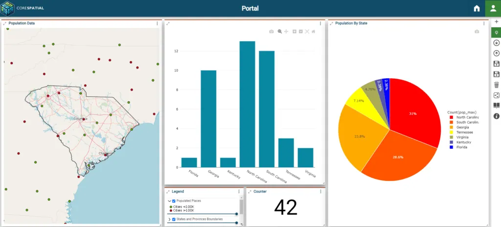
Maps, dashboards, and analysis that let any level of user reach decisions faster.
CoreSpatial 3D
Self-hosted streaming 3D, with global content and 3D Tiles from your own data, built into Portal.
Not sure which CoreSpatial deployment fits your agency?
Explore Buyer's Guides
Rapidly procurable through the DoD Tradewinds Marketplace
CoreSpatial has earned an “awardable” rating in the DoD CDAO Tradewinds Solutions Marketplace, pre-vetted through competitive procedures so federal customers can evaluate and procure it in weeks, not months. From discovery to contract in roughly 45 days.
View on the Tradewinds Marketplace →From secure server to shareable dashboard
CoreSpatial pairs a hardened GeoServer with worldwide basemaps, drag-and-drop imagery management, DHS infrastructure data, and a full MapStore2 portal, so the same authoritative data flows from ingest to analysis to a decision-ready common operating picture.
The same engineering is available as fixed-scope work on your own stack: GeoServer Hardening for a STIG-aligned deployment, and Basemap and Data Provisioning for deployable offline basemap packages.
Worldwide coverage down to the city block
Start from a global OpenStreetMap base and layer in high-resolution imagery, hybrid styling, and critical-infrastructure data wherever the mission needs it, consistent from a theater-wide overview to a single facility.

From flat map to true-to-terrain 3D
With CoreSpatial 3D, a self-hosted deployment of Cesium ion adds streaming 3D to the same Portal. You get global terrain, imagery, and buildings, plus photorealistic 3D Tiles built from your own drone and photogrammetry data. It runs on your infrastructure, connected or fully disconnected.
Explore CoreSpatial 3D
3D imagery: Google Photorealistic 3D Tiles, via Cesium ion
Engineered for secure, high-performance geospatial operations
Technical Specifications
- Engineered excellence: CoreSpatial® features a hardened, optimized version of GeoServer designed for secure, scalable, and high-performance geospatial operations.
- Proactive security: incorporates critical vulnerability updates from CISA.gov, with active mitigations and scheduled updates enhancing security.
- DISA compliance: adheres to DISA best practices, including regular vulnerability scanning and updates, ensuring optimal security posture.
- Performance optimization: fine-tunes the Java Virtual Machine for peak performance and efficient memory usage.
- Reliable and compliant: continual product enhancements and strict adherence to OGC standards ensure operational reliability and seamless interoperability for integrated geospatial analysis.
Use Cases
- Versatile applications: CoreSpatial excels in a variety of uses, from app development to strategic defense and disaster response.
- Defense and strategy: defense agencies rely on CoreSpatial® for superior data integration and analysis, boosting situational awareness and decision precision.
- Disaster response: emergency services use CoreSpatial's real-time visualization for quick, effective strategies during natural disasters, significantly improving response outcomes.
- Mobile and cloud-ready: with packaging for both mobile servers and public clouds, CoreSpatial offers a versatile, anywhere-access solution, suitable for all scenarios.
Integration & Customization
- Adaptive integration: designed for adaptability, seamlessly integrating into existing IT landscapes and offering extensive customization to meet each client's specific operational needs.
- Effortless connectivity: superior integration capabilities ensure effortless connectivity with a wide range of geospatial and enterprise systems, enhancing data collaboration and utility.
- Modular design: clients select the functionalities that best fit their workflows, with support from NGS's custom development services for further customization.
- Custom extensions: NGS crafts unique plugins, modules, and interfaces to tackle specific challenges, delivering solutions that exceed client expectations.
Support & Maintenance
- Comprehensive support: NGS's commitment extends beyond deployment, providing a robust support and maintenance framework to ensure ongoing client success.
- Expert access: clients have direct access to our expert team for technical support, troubleshooting, and operational advice, ensuring swift resolution of any issues.
- Empowering training: tailored training programs enable users to fully harness CoreSpatial's capabilities, enhancing their geospatial proficiency and effectiveness.
- Continuous improvement: NGS regularly updates CoreSpatial with security enhancements, new features, and performance upgrades to maintain its cutting-edge status.
Built on open standards, not black boxes
CoreSpatial is built on proven open-source geospatial software (GeoServer, GDAL, PostGIS, Cesium, and MapStore2), hardened by NGS for secure, high-performance operations. Because it is open and standards-based (OGC WMS, WFS, and WMTS), you get full transparency into every layer of the stack and no proprietary lock-in. Our commitment to open source →
Request a CoreSpatial briefing
Tell us about your environment and we'll set up a demo or technical walkthrough.
See CoreSpatial in action
Deploy from AWS Marketplace with a 30-day free trial, or explore the live demo first.