
CoreSpatial 3D: self-hosted 3D visualization for enterprise GIS teams
CoreSpatial 3D brings a full 3D web viewer to CoreSpatial Portal through a self-hosted deployment of Cesium ion. Global terrain, imagery, and buildings, plus photorealistic 3D Tiles built from your own data, run entirely on your infrastructure. It uses the same secure platform and access controls as every other CoreSpatial module.

3D imagery: Google Photorealistic 3D Tiles, via Cesium ion
A complete 3D platform, not just a viewer
CoreSpatial 3D is delivered as a CoreSpatial module under the standard subscription, with no separate product license and no dependency on an external cloud service. All 3D content and processing run on your own infrastructure, so the capability operates in connected, restricted, and fully disconnected environments.
The power of Cesium ion, on your own network
A self-hosted deployment of Cesium ion runs entirely on your infrastructure, with no reliance on the Cesium cloud or on internet connectivity at runtime. It is the same streaming 3D engine that powers modern geospatial applications, hardened and packaged to operate anywhere the mission does, including air-gapped and restricted networks.
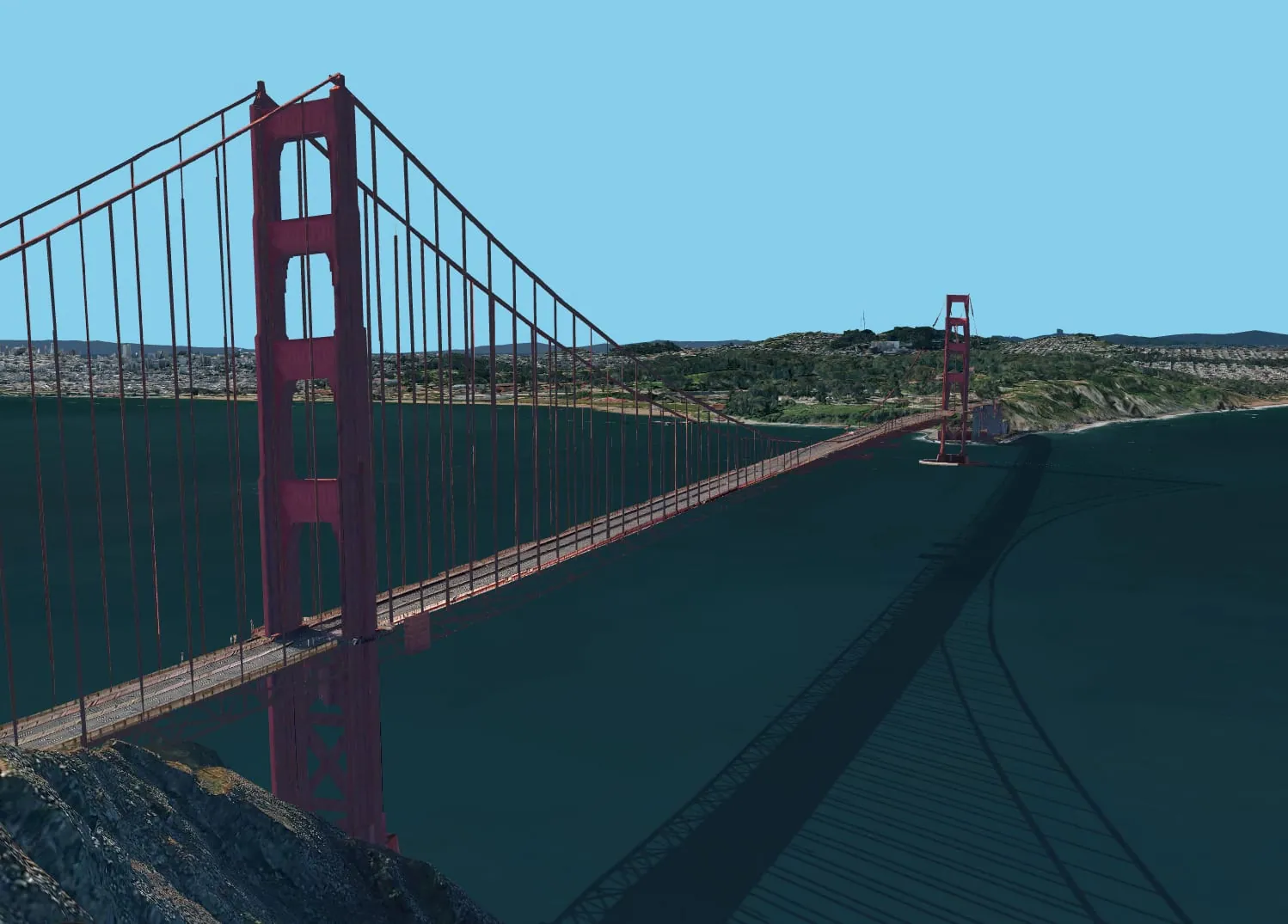
3D imagery: Google Photorealistic 3D Tiles, via Cesium ion
2D and 3D in one common operating picture
CoreSpatial 3D integrates natively into CoreSpatial Portal, so 3D layers combine with your existing 2D services (WMS, WMTS, WFS, and ArcGIS sources) in the same maps, dashboards, and geostories using Cesium 3D Tiles. One environment gives every user a full 3D web viewer and a 2D map viewer, with no context switching between tools.
Explore CoreSpatial Portal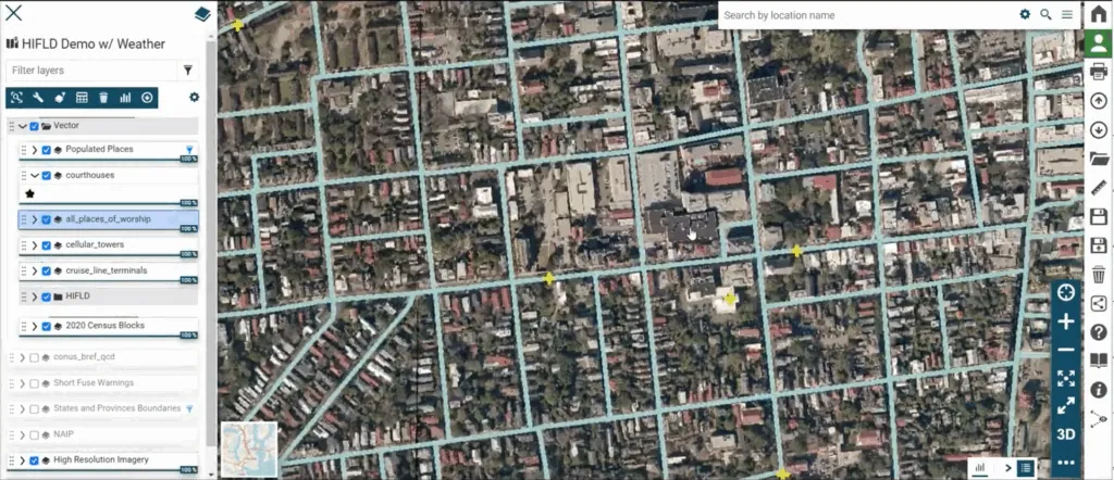
Global 3D content and 3D Tiles from your own data
Global 3D Content, Offline
Ships with global 3D content packaged for offline use, including Cesium World Terrain, Sentinel-2 imagery, and Cesium OSM Buildings. A rich 3D basemap is available even with no connection to the outside world.
3D Tiles From Your Own Data
A CoreSpatial Portal plugin turns your own data, including drone imagery, photogrammetry, and point clouds, into streaming 3D Tiles and photorealistic 3D models. Upload, monitor processing jobs, and publish directly to the map, all from inside Portal.
Integrated Into Your Security Architecture
Because Cesium ion runs on the same infrastructure as the rest of CoreSpatial, 3D content is governed by the same access controls, update cadence, and support model as every other module, with no additional vendor relationship to manage.
Native 2D/3D Interoperability
Built on open standards and Cesium 3D Tiles, CoreSpatial 3D layers sit alongside your authoritative 2D services in the same views, turning a flat common operating picture into an interactive, true-to-terrain 3D one.
How to evaluate self-hosted 3D GIS software
Enterprise GIS directors comparing 3D geospatial visualization platforms tend to ask the same six questions. Here is how CoreSpatial 3D answers each one.
- Who controls the infrastructure? CoreSpatial 3D runs a self-hosted Cesium ion on your own servers. Nothing depends on the Cesium cloud or an internet connection at runtime.
- Can it handle large terrain and imagery? Content is streamed as Cesium 3D Tiles, so the viewer loads only the detail it needs for the current view instead of the whole dataset.
- Can it process your own data? Raw LiDAR, drone imagery, and photogrammetry are processed into 3D Tiles and photorealistic 3D models from inside CoreSpatial Portal.
- Does 3D work alongside 2D? 3D layers sit in the same maps and dashboards as your WMS, WMTS, WFS, and ArcGIS services, so analysts never switch tools.
- Is it built on open standards? Yes. CoreSpatial 3D uses Cesium 3D Tiles, an OGC Community Standard, and the rest of CoreSpatial is built on GeoServer, PostGIS, GDAL, and MapStore2.
- Who secures and supports it? NGS. 3D content follows the same access controls, quarterly release cadence, and support model as every other CoreSpatial module.
Evaluating Esri as well? See CoreSpatial 3D vs Esri for secure government GIS.
CoreSpatial 3D specifications
| 3D engine | Cesium ion, self-hosted on your infrastructure |
|---|---|
| Included global content | Cesium World Terrain, Sentinel-2 imagery, Cesium OSM Buildings, packaged for offline use |
| Your own data | LiDAR, drone imagery, and photogrammetry processed into 3D Tiles |
| Output format | Cesium 3D Tiles |
| 2D services in the same view | WMS, WMTS, WFS, and ArcGIS sources via CoreSpatial Portal |
| Environments | Connected, restricted, and fully disconnected networks |
| Licensing | Included as a module in the CoreSpatial subscription, priced per deployment rather than per user or per CPU |
 Partnership
Powered by Cesium, delivered by NGS
NGS is a certified Cesium Developer Organization. CoreSpatial 3D pairs Cesium's 3D geospatial platform with NGS's hardened, secure CoreSpatial architecture and hands-on support, giving your team real-time 3D visualization without a separate cloud dependency or vendor to manage.
See our Cesium certificationAdditional products
CoreSpatial 3D questions
What is CoreSpatial 3D?
CoreSpatial 3D is the 3D geospatial visualization module of CoreSpatial by NGS. It adds a self-hosted deployment of Cesium ion to CoreSpatial Portal, giving enterprise GIS teams streaming 3D terrain, imagery, buildings, and 3D Tiles built from their own data, all on their own infrastructure.
Can CoreSpatial 3D run without an internet connection?
Yes. Cesium ion and the global 3D content run on your own servers, so CoreSpatial 3D works in connected, restricted, and fully disconnected environments with no call out to a cloud service at runtime.
What data can I turn into 3D?
Raw LiDAR, drone imagery, and photogrammetry. A CoreSpatial Portal plugin lets you upload the data, monitor processing jobs, and publish the resulting 3D Tiles straight to a map.
Do I need a separate license for 3D?
No. CoreSpatial 3D is delivered as a module under the standard CoreSpatial subscription, which is priced per deployment rather than per user or per CPU.
How does CoreSpatial 3D compare to other 3D GIS software?
The main difference is where it runs. CoreSpatial 3D is fully self-hosted and built on open standards, so you keep control of the infrastructure and the data, and 3D sits in the same Portal as your existing 2D OGC and ArcGIS services. Request a briefing for a side by side against the tools you are evaluating.
Request a CoreSpatial 3D briefing
Tell us about your environment and we'll set up a demo or technical walkthrough.
See CoreSpatial 3D in action
Explore the live demo, or talk to our team about bringing self-hosted streaming 3D to your mission.